🌨️ Why Snow Depth Reduces Even in Cold Weather
Even when it’s below freezing, snow doesn’t stay at its original depth:
- Compaction: Snow crystals settle under their own weight, reducing depth.
- Wind redistribution: Blowing snow can erode surface layers.
- Sublimation: Snow slowly evaporates directly into water vapor, especially in dry, sunny conditions.
- Metamorphism: Snow crystals change shape, becoming denser and less fluffy over time.
📉 Typical Reduction Rates
Research on mountain snowpacks shows:
- Fresh powder (light, fluffy snow): Loses depth quickly, often 10–20% in the first 24 hours.
- Settled snowpack: After initial compaction, reduction slows to ~0.5–1 cm per day if temperatures stay below freezing.
- Cold, shaded areas: Snow can last for weeks with minimal reduction.
- Sunny, dry conditions: Sublimation accelerates losses even without melting.
🏔️ Example Scenario
- Day 0: 10 cm fresh snow falls.
- Day 1: Compaction reduces it to ~8–9 cm.
- Day 3–5: Depth stabilizes around 6–7 cm.
- Day 7+: If no new snow arrives, expect ~4–5 cm remaining, thinning further over time.
⚖️ Key Variables
- Temperature: Below freezing slows melt but doesn’t stop compaction.
- Humidity & Sunlight: Dry air and strong sun speed sublimation.
- Snow type: Powder compresses faster than wet snow.
- Wind exposure: Can strip snow from exposed slopes.
❄️ Key Takeaways
Even in consistently cold conditions, snow depth decreases daily. On average, expect 0.5–2 cm reduction per day after the initial compaction phase. So a 10 cm snowfall might last a week or more, but it won’t stay at full depth unless reinforced by new snowfalls.
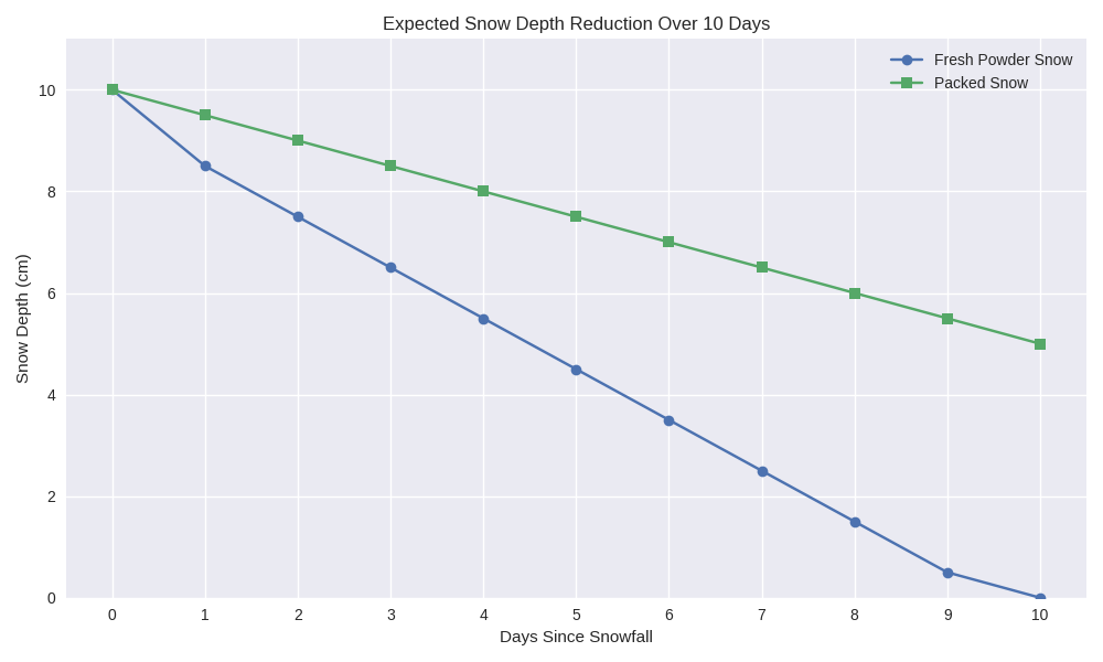
🌨️ What the Chart Shows
- Fresh Powder Snow (blue line):
- Loses ~15% depth in the first day (10 cm → ~8.5 cm).
- Then compacts by ~1 cm per day.
- By Day 10, only ~0.5–1 cm remains.
- Packed Snow (orange line):
- Reduces more slowly, ~0.5 cm per day.
- By Day 10, ~5 cm remains.
❄️ Key Takeaways
- Powder shrinks fast: fluffy crystals collapse under their own weight.
- Packed snow lasts longer: denser structure resists compaction.
- Even without melting, expect 0.5–2 cm loss per day depending on snow type, sun, and wind.
🏂 What Skiers & Snowboarders Should Look For
To maximize powder days, riders chase specific weather and terrain signals:
- Recent Snowfall Totals: Fresh dumps of 20+ cm are ideal, but even 10 cm can deliver if conditions align.
- Snowfall Intensity & Timing: Overnight storms are gold — resorts wake up with untouched powder.
- Temperature Trends: Cold temps (below freezing) preserve snow quality; warming leads to heavy, sticky snow.
- Wind Direction & Speed: Wind can strip exposed slopes but also create deep stashes in leeward bowls.
- Elevation & Aspect: Higher altitudes and north-facing slopes hold powder longer.
- Storm Cycles: Multiple days of consistent snowfall build a deep base and reset conditions.
- Moisture Content: “Cold smoke” (low water content) is the dream — light, dry, blower powder.
❄️ How Find Powder’s AI Weather Model Can Build This In
Your AI can go beyond raw forecasts by translating meteorology into rider-friendly powder signals:
- Powder Index (0–100): A composite score combining snowfall, temperature, wind, and aspect to rate powder potential.
- Storm Alerts: Push notifications when overnight snowfall + cold temps align for a “powder day.”
- Persistence Modeling: Estimate how long fresh snow will stay fluffy (e.g., “10 cm at Zermatt will ski like powder for ~2 days”).
- Microclimate Insights: Highlight slopes/aspects where powder lingers (north-facing, shaded gullies).
- AI-Powered Forecast Narratives: Instead of raw numbers, deliver rider-focused summaries like:
“Expect knee-deep turns on sheltered north slopes tomorrow; wind-exposed ridges will be scoured.”
- Community Layer: Let riders tag and confirm powder conditions, feeding back into the AI for real-time accuracy.
That’s the kind of rider-first intelligence that makes Find Powder indispensable.